There have not been any airfield condition assessments for roughly 10 years since the 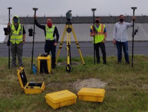 Iwakuni Runway Relocation Project (IRRP) completed. The airfield currently sits on reclaimed land, where its earth is from the nearby Atago Mountain. Subsidence and soil liquefaction are the two most concerned land reclamation issues. Therefore, in order to help the Airfield Operations better understand the state and evaluate life span extension possibilities of the airfield, the geocgi MCASI team collaborated with the Engineering Branch, Maintenance Control Branch, and MWSS-171 to conduct a comprehensive airfield condition assessment that includes discovering, identifying, and recording the location of chips, cracks, vegetation, and most importantly, surveying the elevation, using GPS equipment. The results were imperative and beneficial for the installation in terms of airfield planning, maintenance, and repair. For more information on our airfield condition assessment or other efforts, please email info@geocgi.com.