We recently worked at James Madison’s Montpelier to analyze different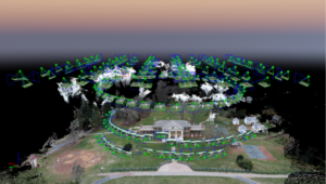 methods for developing detailed 3D models with our sUAS equipment. With the permission of the Director of Archaeology and Landscape Restoration, Matt Reeves, our sUAS team performed three missions, each with a different flight pattern, altitude, and camera angle to determine if one method would produce noticeably better 3D outputs. We used our DJI Inspire 2 with a Zenmuse x4s sensor on board, and we set up the flight patterns and specifications in Pix4D Capture. The first mission was flown at 200 ft, with the camera pointed at a 70-degree angle, as the drone flew in a double grid over the mansion. Our second mission was flown in a circle around the building at 150 ft with a 60-degree camera angle. Our third and final mission was flown manually to account for the rectangular shape of the building, varying elevation, and placement of trees. The third flight’s altitude was set at 50 ft, as the operator methodically positioned the drone for each image. We post-processed the results in Pix4D and Esri’s Drone2Map and published the final 3D output here.
 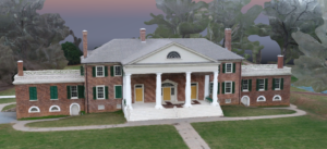 Tell us what you think about our approach by sending us an email at sUAS@geocgi.com.